What the Santiam Silt Data MeansReading the North Santiam River Before and During the Detroit Dam Drawdown
Since October we have been driving the Santiam Canyon with a cooler of sample bottles, filling them at six public access points between Detroit Lake and Mehama, and publishing every result at santiamsilt.com. Here is what those five numbers per bottle actually tell you, what the first two runs show, why we collect them on a schedule when federal gauges run around the clock, and why we think a plain public record of this river matters right now.
11 min read · Waterlab Corp Laboratory Staff · Current as of November 8, 2026
Where things stand on the river
The U.S. Army Corps of Engineers plans to lower Detroit Reservoir to 1,425 feet this fall in a deep drawdown, an operation it says is required under the December 2024 federal Biological Opinion so that juvenile Upper Willamette spring Chinook and winter steelhead can pass downstream through a lower outlet in the dam.
The Corps set a window of November 1 through December 31, 2026, with the start date chosen from forecast conditions. It expects about two weeks to reach 1,425 feet and about two weeks holding there before refill. In later years the target drops to 1,395 feet. The Corps describes turbidity as the risk it manages during the operation, not a goal of it.
Salem, Marion County, Stayton and the Santiam Water Control District sued to stop it, arguing that mobilized sediment could overwhelm the slow sand filtration plants downstream. On November 4, 2026, U.S. District Judge Mustafa T. Kasubhai denied the request for a preliminary injunction, finding the harm possible but not shown to be likely. The denial was without prejudice, and Marion County said it would ask the Ninth Circuit for an emergency injunction.
As of this writing the Corps had not announced a start date; news reports point to late November. The drawdown news page on Santiam Silt carries the current status, and our earlier guide to the Detroit Dam drawdown and Salem's lawsuit explains how the dispute got here.
Why we started sampling
We are a water testing laboratory in Salem. The North Santiam is our own drinking water and our customers' drinking water, and the argument over the drawdown is an argument about numbers: how cloudy, for how long, and how far downstream. Most of those numbers were coming from either the agency running the dam or the parties suing it.
We had the instruments, the training and the sample bottles, so in October we started building a third record: grab samples from public access points along the river, tested the same way we test any customer's water, published in full with nothing estimated or filled in.
Why we collect what we collect
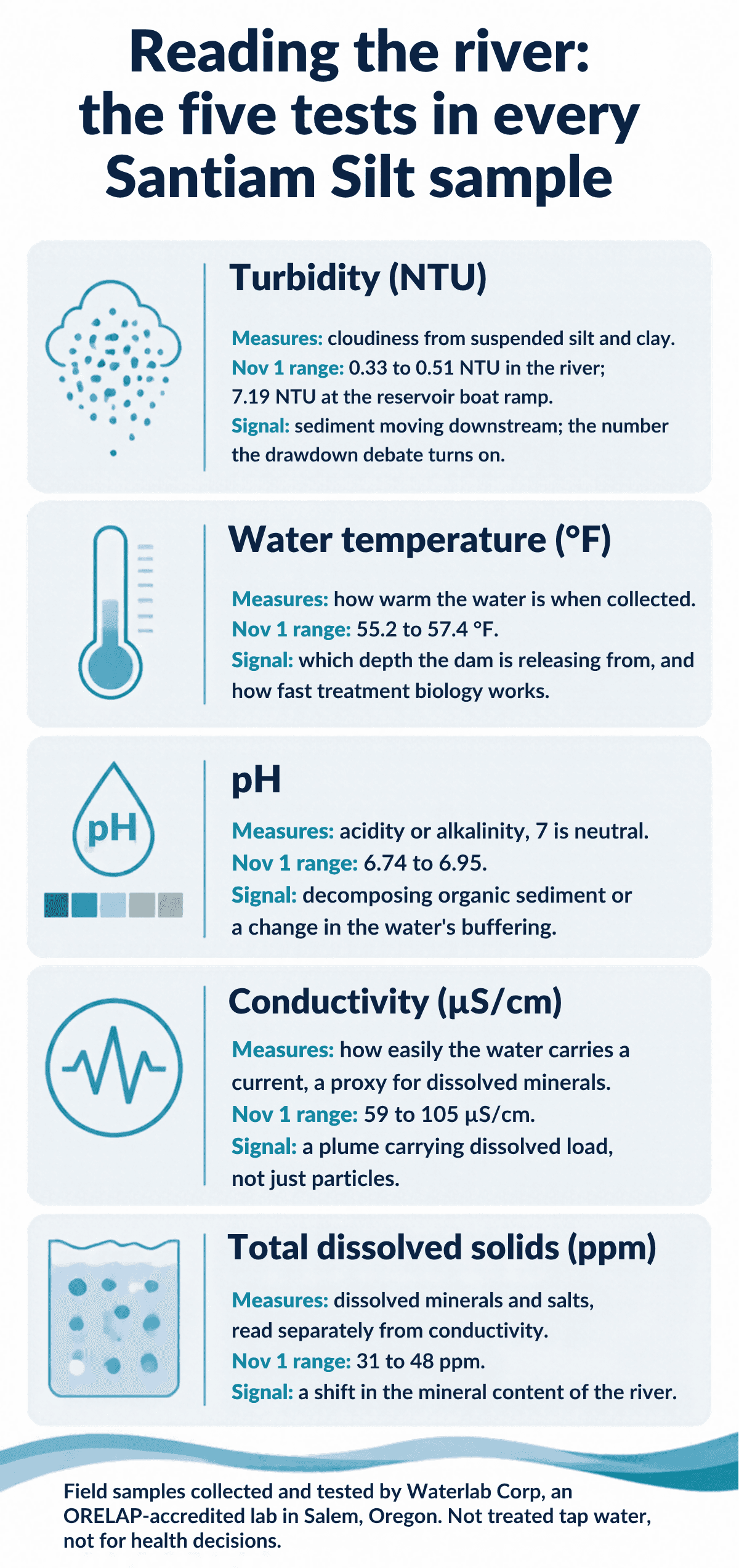
Every bottle gets the same five tests. Turbidity is the one everyone is watching. The other four are what let us say something useful about a turbidity change when it comes: where the water came from, what it is carrying, and whether the sediment is changing the chemistry of the river or just its clarity.
Turbidity (NTU)
Nov 1: 0.33 to 0.51 NTU in the river, 7.19 NTU at the reservoir boat ramp
Cloudiness from suspended silt and clay. It is the measurement the drawdown debate turns on, because sediment stirred up behind Detroit Dam shows up here first. Turbidity is not itself toxic, but it clogs slow sand filters, shields microbes from disinfection, and is the number Salem asked the court to use as a pause threshold (10 NTU).
Water temperature (°F)
Nov 1: 55.2 °F at the Detroit tailrace, warming to 57.4 °F near Mehama
Temperature tells us where in the water column the dam is releasing from. Deep water in a stratified reservoir runs cooler than the surface in fall, so a cold tailrace means a deep release. It also sets the pace of the biology in a slow sand filter and matters to the salmon the drawdown is meant to help.
pH
Nov 1: 6.74 to 6.95, slightly below neutral at every station
Acidity or alkalinity on a 0 to 14 scale. Soft snowmelt water has little buffering, so it sits a bit under 7 and can move more easily than hard water would. A drop during the drawdown could point to decomposing organic material in mobilized sediment; a shift either way changes how corrosive the water is to pipes.
Conductivity (µS/cm)
Nov 1: 59 at the reservoir, 62 and 71 below the dams, 73 at Fishermen’s Bend, 105 near Mehama
How readily the water carries an electric current, which rises with dissolved minerals and salts. It is the quickest field check on the water’s dissolved load. If turbidity spikes while conductivity barely moves, the plume is particles; if they rise together, the sediment is giving up dissolved material too.
Total dissolved solids (ppm)
Nov 1: 31 ppm at the upper three stations, 41 and 48 ppm downstream
The minerals and salts actually dissolved in the water, measured on its own rather than estimated from conductivity. Anything under about 50 ppm is very soft; the EPA’s taste guideline is 500. TDS is the slow-moving twin of conductivity and the one most people recognize from their own water test.
What the first two runs show
The October 16 run was turbidity and conductivity only, at four stations. The November 1 run was all five tests at five stations; Packsaddle Park near Gates gets its first sample in mid-November. Two runs are not a trend, but they are enough to show the river's shape before anything happened.
Turbidity: a cloudy lake and a clear river
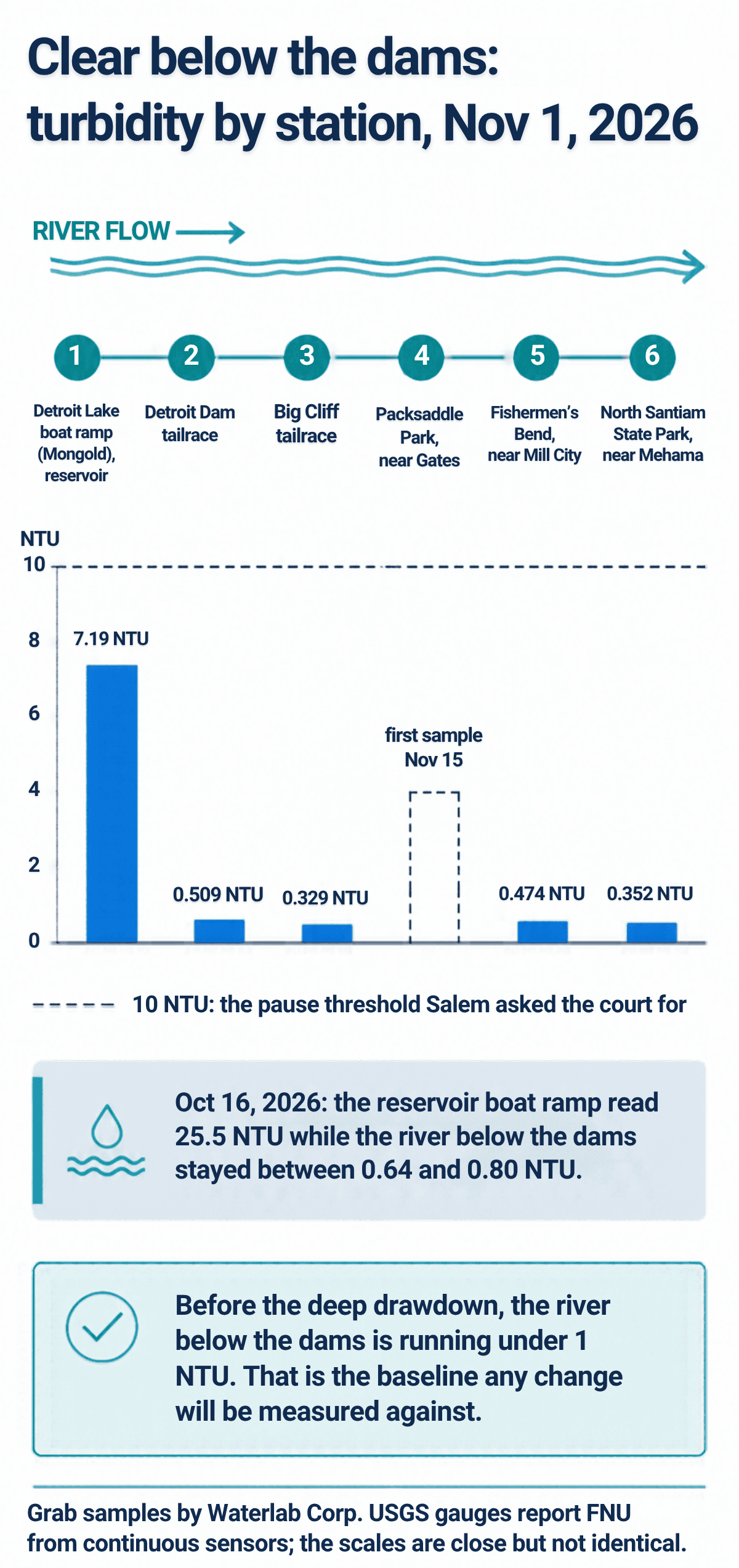
- October 16: the reservoir sample at the Mongold boat ramp read 25.5 NTU while the three river stations below the dams read 0.64, 0.71 and 0.80 NTU.
- November 1: the ramp had dropped to 7.19 NTU and the river was even clearer: 0.51 at the Detroit tailrace, 0.33 below Big Cliff, 0.47 at Fishermen's Bend and 0.35 at the North Santiam State Park ramp.
For scale, Salem asked the court to pause the drawdown at 10 NTU, and the EPA's limit for finished drinking water leaving a filtration plant is well under 1.
The gap between the ramp and the tailrace is the most useful thing in the data so far. The boat ramp is a shallow, wind-worked edge of a lake that was already low on November 1, with stumps showing on the lakebed. The tailrace is water pulled from depth through the dam.
In the fall the reservoir still acts as a giant settling basin: the fine material stirred up at the margins has not been reaching the outlets. Big Cliff, the small reregulating dam just downstream, then evens out Detroit's releases before the river runs free through the canyon. The result is a river below the dams that is, for now, cleaner than most Oregon tap water requirements demand of a treatment plant.
That is exactly why the baseline matters. When the Corps opens the lower outlet and the lake drops toward 1,425 feet, the question is whether the tailrace starts to look like the boat ramp. If it does, the next question is whether the canyon and the forty-odd river miles to the Stayton and Salem intakes knock the number back down, or whether it carries through. Our stations are placed to answer both.
Conductivity and TDS: soft water with a downstream drift
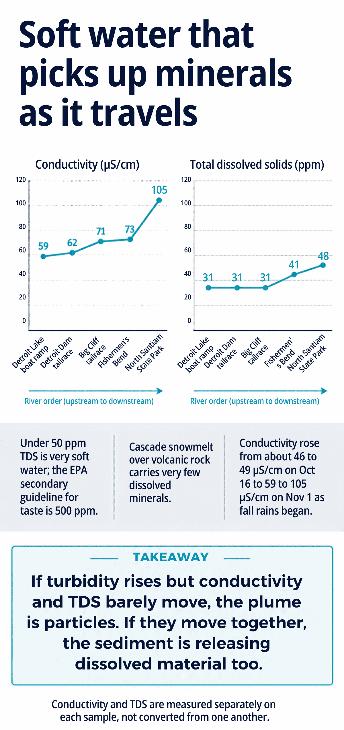
The North Santiam is about as soft as river water gets. Snowmelt moving over young volcanic rock simply does not dissolve much.
November 1, upstream to downstream:
- TDS: 31 ppm at the reservoir and at both tailraces, 41 ppm at Fishermen's Bend, 48 ppm at the state park ramp.
- Conductivity: 59 µS/cm at the ramp, 62 and 71 below the two dams, 73 near Mill City, 105 near Mehama.
For comparison, a typical Willamette Valley well runs several hundred µS/cm, and the EPA's secondary guideline for TDS in drinking water is 500 ppm.
The rise down the canyon is what you would expect. Side creeks, groundwater seeping in from the canyon walls and the first fall rains all carry more dissolved material than the lake does. The whole river also shifted up between the two runs, from 46 to 49 µS/cm everywhere on October 16 to 59 and higher on November 1, as the rains began. None of that is a concern.
What makes these two numbers worth running on every bottle is what they will tell us when turbidity moves. A plume that is all particles leaves conductivity and TDS roughly where they were. A plume that is releasing dissolved material from decades of settled sediment moves them together with the turbidity, and that is a different problem for a treatment plant.
Temperature and pH: steady, and telling
The coolest water on November 1 was the Detroit tailrace at 55.2 °F. The river warmed gently to 56.1, 56.8 and 57.4 °F downstream, while the lake surface at the ramp sat at 57.0.
A tailrace cooler than the lake surface in November means the dam is releasing from depth, which is also where the oldest sediment sits. We will be watching whether that pattern holds as the outlet changes.
pH ran from 6.74 to 6.95, just under neutral at every station. That is normal for soft water with little alkalinity to buffer it, and Oregon's aquatic life criterion for this basin is 6.5 to 8.5, so there is room on both sides.
The reason to keep measuring it is that soft water moves easily. Decomposing organic material in disturbed sediment tends to pull pH down, and a shift in either direction changes how the water behaves in pipes and filters. So far it has not budged.
Why scheduled samples and live data belong together
We can only be on the river every couple of weeks. A drawdown plume could arrive and pass between two visits. That is why Santiam Silt leans on two other records, and why each of the three does a job the others cannot.
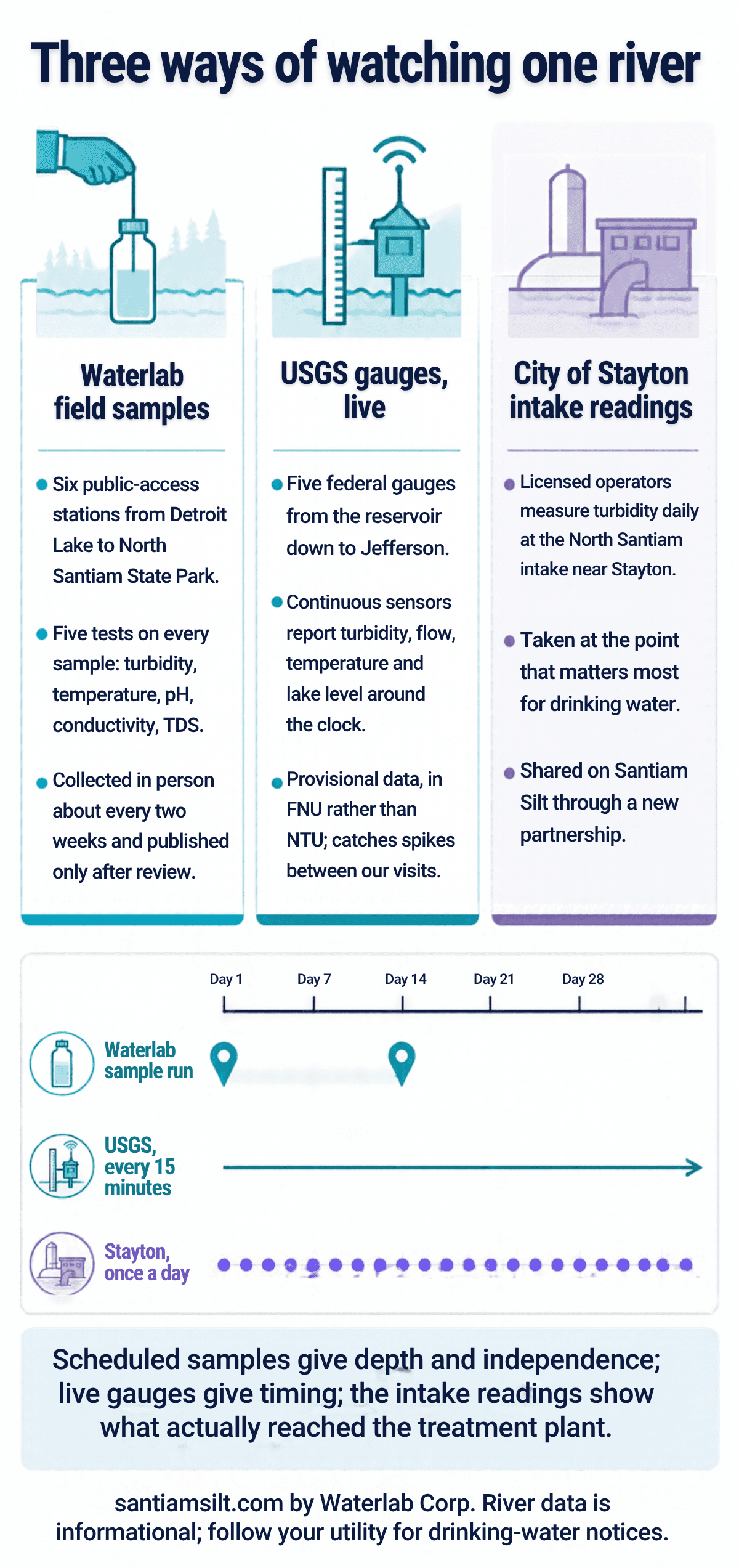
Waterlab field samples
- Six public-access stations: the Mongold boat ramp on Detroit Lake, the Detroit and Big Cliff tailraces, Packsaddle Park near Gates, Fishermen’s Bend near Mill City, and the North Santiam State Park ramp near Mehama.
- Five tests on every sample, run on lab instruments: turbidity, temperature, pH, conductivity and TDS.
- Collected in person about every two weeks and published only after review. Nothing is estimated; a test that was not run shows as NA.
USGS gauges, live
- Five federal gauges: Detroit Lake near Detroit, the river at Niagara below Big Cliff, at Mehama, below Stout Creek near Mehama, and at Greens Bridge near Jefferson.
- Fixed sensors report turbidity, flow, temperature and lake elevation around the clock, typically every 15 minutes.
- Provisional data in FNU rather than NTU. The scales are close but not interchangeable, so we compare timing and direction, not decimals.
City of Stayton intake readings
- Licensed water system operators measure turbidity every day at the North Santiam intake near Stayton, where the river reaches the slow sand plants that supply Stayton, Salem and neighboring communities.
- Through a partnership set up this month, the city is beginning to share that daily record on Santiam Silt, always credited to the city.
- It is the measurement taken at the point that matters most for drinking water, and it fills the days between our visits.
The USGS gauges are the backbone. They never sleep, they have years of history behind them, and the gauge at Niagara sits just below Big Cliff, where a drawdown plume would show first. But a fixed sensor reads one spot in one way, in FNU from an optical probe, and the data is provisional until the agency reviews it. Our grab samples add stations the gauges do not cover, four more parameters, lab instruments, and a second independent reading of turbidity in NTU. The City of Stayton's operators add the one measurement everyone downstream actually cares about: what the river looked like when it arrived at the intake that feeds the slow sand plants.
Read together, the three records let you answer the questions that matter in the right order. Did something change? The gauge says when. How much, and what kind? Our samples say what was in it. Did it reach the plant? Stayton's log says so. You can watch all three in one place on the Santiam Silt dashboard, and the USGS WaterAlert service will text you when a gauge crosses a turbidity level you choose.
Why we think this project matters
Fish passage and dependable drinking water are both real public goods, and the people arguing about them in court are all acting in good faith on incomplete information. A public record nobody has to take on faith is the one thing we can add.
A baseline, before anything happened
You cannot say what a drawdown did to a river unless you know what the river was before. Two runs in October and early November put numbers on “normal” for every station: under 1 NTU below the dams, soft water around 60 to 100 µS/cm, pH near 6.8, mid-50s temperatures.
Independent of everyone with a stake
The Corps operates the dam. The cities are suing it. The gauges are federal. Waterlab is a Salem lab that depends on this river like everyone else here, and the project is paid for by the lab, published in full, and not for anyone’s case.
One source, ten communities
From Detroit and Idanha to Stayton, Salem and Turner, about ten communities and some 200,000 people draw on the North Santiam watershed. Much of that water is treated by slow sand filtration, a method that works beautifully on clean water and poorly on muddy water.
The question the court left open
On Nov 4, 2026, the judge declined to pause the drawdown, finding that harm to drinking water was possible but not shown to be likely. The denial was without prejudice. Whether the concern was warranted will be settled by what the river actually does this winter, and that is a question of data.
What we will be watching once the drawdown starts
- Turbidity at the Detroit tailrace (station 2) relative to the reservoir boat ramp (station 1). If the release starts to look like the surface, sediment is on the move.
- Whether Big Cliff and the canyon knock the number back down by Fishermen’s Bend and North Santiam State Park, or whether it carries through.
- The USGS gauge at Niagara between our visits, and the Stayton intake readings on the days we are not on the river.
- Conductivity and TDS moving with turbidity rather than staying flat, which would mean dissolved material is coming off the sediment.
- A pH drift downward below the dams, which we have not seen yet.
- Lake elevation on the Santiam Silt dashboard. The deep drawdown target is 1,425 feet; the Corps says it takes about two weeks to get there, followed by about a two-week hold.
What this data is not
It is river and reservoir water, not treated tap water, and it is not a regulatory or health record. The cities and districts on the North Santiam test their finished water constantly and will issue notices if anything changes at your tap. For your own drinking water, follow your utility. If you are on a private well near the river and want to know what is in it, that is what a residential water test is for.
Sources and further reading
Field results quoted here are from the Santiam Silt sampling runs of October 16 and November 1, 2026. Court and schedule details are as reported through November 8, 2026, and will change; check the live pages below.
- Santiam Silt — North Santiam River water test results (every published sample)
- Santiam Silt — live dashboard with the USGS gauges and lake level
- Santiam Silt — Detroit Lake drawdown schedule, news and lawsuit updates
- U.S. Army Corps of Engineers, Portland District — Detroit Dam 2026 drawdown information
- City of Stayton — Detroit Dam drawdown resources and updates
- USGS — North Santiam River at Niagara, OR (gauge 14181500)
- USGS WaterAlert — text or email alerts when a gauge crosses a turbidity threshold
Related reading: the Detroit Dam drawdown and Salem's lawsuit, how municipal water systems work, and hardness, calcium and TDS explained.
Follow the river, or test your own water.
Every published sample, the live gauges and the drawdown status are on santiamsilt.com. If you draw from a well near the river, we can tell you what is in it.